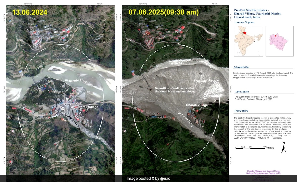
The Indian Space Research Organisation (ISRO) has been playing a pivotal role in enhancing disaster management efforts across the country, particularly in regions prone to natural calamities. Recently, its advanced satellite imagery and data analytics have significantly aided disaster relief operations in Uttarkashi, a district in the Indian state of Uttarakhand that is frequently affected by landslides and other environmental disruptions. By leveraging satellite technology, ISRO has provided critical insights that facilitate timely response and recovery measures during emergencies, ensuring that relief operations are both efficient and effective.
Satellite data from ISRO offers comprehensive views of affected areas, allowing authorities to assess damage and prioritize relief efforts. For instance, high-resolution imagery enables the identification of landslide-affected zones, monitoring of affected infrastructure, and analysis of the movement of people and resources. This information is crucial for local administrators and rescue teams as it helps them devise strategies to deliver aid to the most impacted regions promptly. Furthermore, the real-time monitoring capabilities of ISRO satellites allow for continuous updates on changing conditions, which is essential for adapting relief strategies as situations evolve on the ground.
In addition to immediate disaster response, ISRO’s satellite insights contribute to long-term disaster preparedness and mitigation strategies in Uttarkashi. By analyzing historical data, officials can identify patterns and vulnerabilities in the region, leading to better planning and infrastructure development that minimizes future disaster risks. This proactive approach not only enhances community resilience but also fosters a culture of preparedness, where local populations are better equipped to respond to emergencies when they arise.
Overall, ISRO’s satellite technology underscores the importance of integrating scientific advancements into disaster management frameworks. By providing invaluable data that informs decision-making, ISRO not only supports immediate relief efforts but also contributes to building a more resilient future for Uttarkashi and similar disaster-prone areas in India. The collaboration between space technology and ground-level operations exemplifies how innovative solutions can significantly enhance the efficacy of disaster response and recovery initiatives.